Hurricane Nadine Oscar National Hurricane Center NHC Tracker Path Tropical Storm Spaghetti
[Image Credit: National Hurricane Cneter]

Here’s Where Hurricanes Nadine & Oscar Could Form According to The National Hurricane Center

The potential formation for Hurricane Nadine and Hurricane Oscar is being monitored by the National Hurricane Center, according to its two-day outlook for Tuesday, October 15. Two low-pressure systems that could develop into tropical storms were already being tracked on Friday last week by weather experts who were looking at various models for possible storms after Hurricane Milton. But this marks the first time that the NHC has made a forecast about these two disturbances in the same report. Residents along the Gulf coast have been concerned about hurricanes after both Milton and Helene caused widespread flooding and high storm surges throughout the southeastern United States.

The NHC officially tracking possible formation of hurricanes Nadine & Oscar

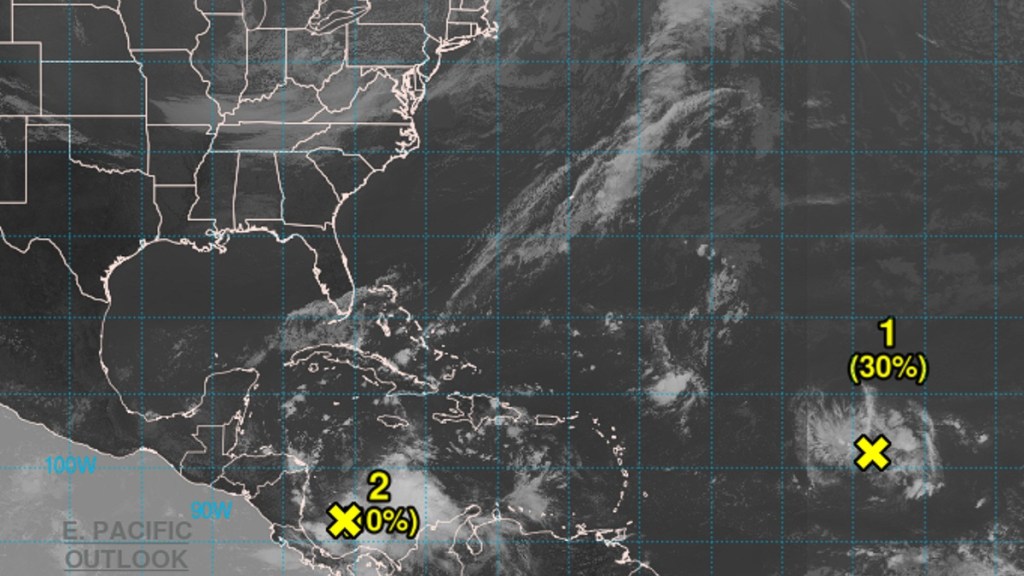
The possible formation of Hurricane Nadine and Oscar is greatest with an area of low pressure that is moving over the center of the Atlantic Ocean. This is according to a report by the NHC on October 15 at 10:00 AM PDT / 1:00 PM EDT stating that it has a 30% chance of formation over the next 48 hours and 50% chance of formation over the next 7 days.

This system, labelled AL94, is moving “generally westward” from the western coast of Africa and conditions appear that it may develop in strength “by the middle to latter part of this week.” The NHC notes that it could form a tropical depression as it approaches “near the Leeward Islands late this week.” The Leeward Islands include the Virgin Islands east of Puerto Rico.

[Image Credit: NCAR]

Pictured above is a spaghetti model of this disturbance as tracked by the National Center for Atmospheric Research (NCAR) on October 15 at 5:00 AM PDT / 8:00 AM EDT. Most projections have the system moving due west and potentially over Haiti and The Dominican Republic over the next five days.

Mr. Weatherman, also known as meteorologist Brian Shields on YouTube, notes on Tuesday that the CMC model from Canada has this system turning into a hurricane where as the ICON hurricane model has it become only a tropical storm. Both the European and American models don’t have it forming into a tropical storm yet.

Hurricane expert Alex DaSilva of AccuWeather believes that this Atlantic feature will build in strength due to warm water and low wind shear. This is why he has upgraded the system to a “tropical rainstorm,” noting that it could “ramp up quickly” into a tropical depression, tropical storm, or hurricane. As for whether it might hit Florida, that’s still unclear, but its path toward the state is currently being “blocked” partially by a high-pressure system hovering over the southeastern United States.

The other notable system being tracked by the NHC is a broad low-pressure area in the southwestern Caribbean Sea close to the northern coasts of Panama and Costa Rica. It believes that if the system continues to stay over water, it could develop into a tropical storm as it moves northwest toward Central America. That said, potential formation is relatively low, only 10% over the next 48 hours and 20% over the next 7 days. Either way, it predicts that portions of Central America will experience “heavy rainfall.”

Shields reports that only the American GFS model has this system become a tropical storm, whereas the other three models do not. If it moves over Central America, it will likely lose some strength over the week, though if it remains over the water along the region’s eastern coastline, it has the chance of spinning up further.

Fortunately for the United States, according to DaSilva, this feature is still a “very weak storm” and its the northward path is likewise being “blocked and should stay blocked.” At the time of writing, no spaghetti model from NCAR is yet available for this system.

TRENDING
No content yet. Check back later!

X